English
中文
日本語
Русский
Applications
Robotics & Engineering
Drones, Swarms &
Mobile Robots
Robotic Arms
Exoskeletons
& Wearables
Bionic Robots
Robotic
Hands
Marine &
Underwater
Applications
Medical
Robots
Displacement
Measurement
Virtual Reality
Cost-Effective, Low-Latency, High-Precision VR Tracking
Life Sciences
High Precision, Flexible Motion Capture and Gait Analysis Tools
Entertainment
For Game CG, VFX, 3D Animation, and Motion Capture Studios
Products
Main Portfolio
Cameras
Mars Series
Underwater Cameras
Pluto Series
Orbit Series
Software
Sync Device
Accessories
AI MoCap
Markerless Mocap
Packages
VRT Tracking Package
Robotics
Crazyflie & Crazyswarm
Developer Tools
Multi-modal Data Capture & Management
Integrations
View All Integrations
Support
Support
Documentation
Downloads
FAQs
Resources
News & Events
Case Studies
Motion Capture
Essentials
Related Papers
IROS 2025
Special Section
About
About us
Contact
What is
Motion Capture?
Distributors
Capturing Motion,
Crafting Stories
Explore Our Case Studies: Transforming Motion into Masterpieces Across Industries
Client
Capture volume
Application
Objects
Equipment used
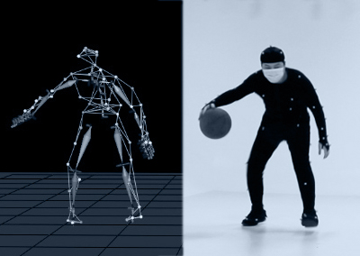
NOKOV Motion Capture Basketball Game Demo
UMI Game
2022-03-29
Kung Fu Motion Capture Performance
Shu-Gu Entertainment
2023-02-06
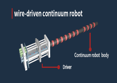
Applications of motion capture systems in wire-driven continuum robot research
Sichuan University
2022-06-17
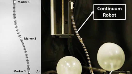
Efficient Trajectory Planning for Continuum Robots (based on RRT*)
Southern University of Science and Technology
2024-06-04
By using this site, you agree to our
terms
, which outline our use of cookies.
CLOSE
×
Contact us
We are committed to responding promptly and will connect with you through our local distributors for further assistance.
Engineering
Virtual Reality
Life Sciences
Entertainment
I would like to receive a quote
Submit
Beijing NOKOV Science & Technology Co., Ltd (Headquarter)
Room820, China Minmetals Tower, Chaoyang Dist., Beijing
info@nokov.cn
+ 86-10-64922321
Capture Volume
*
Objective
*
Full Bodies
Drones/Robots
Others
Quantity
Camera Type
Pluto1.3C
Mars1.3H
Mars2H
Mars4H
Underwater
Others/I do not know
Camera Count
4
6
8
12
16
20
24
Others/I don't know